Map of Plitvice Lakes National Park: A Complete Guide to Navigating the Park
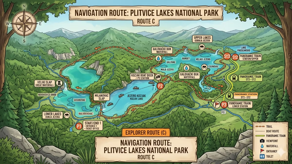
Plitvice Lakes National Park is divided into two main sections: the Upper Lakes (12 lakes, accessed from Entrance 2 in the south) and the Lower Lakes (4 lakes, accessed from Entrance 1 in the north). The two sections are connected by electric boat across Lake Kozjak. The park has three boat terminals (P1, P2, P3) and three panoramic train stops (ST1, ST2, ST3). Seven official walking routes are marked A through K (with no D, G, I, or J). The park covers approximately 296 km² of forested karst terrain, though the lake and boardwalk network — the section most visitors explore — spans approximately 18 km of trails. Official printed maps are available at both entrances; a digital map is also available on the official park website.
Plitvice Lakes looks complicated on a map at first glance. Two sections, two entrances, seven routes with non-sequential letter designations, three boat terminals, three train stops, and 16 lakes — all spread across a forested landscape without a single road running through it. In reality, the park is very well signposted and easy to navigate once you understand the underlying logic. This guide explains that logic clearly, so you arrive at the entrance knowing exactly where you are, where you need to go, and how the pieces fit together.
How the Park Is Laid Out
Plitvice Lakes National Park stretches north to south along the D1 national road in the Lika region of central Croatia. The simplest way to understand the layout is to think of it as two zones separated by a large lake.
The Lower Lakes (Donja jezera) occupy the northern section of the park — closest to Zagreb when driving south. Four lakes cut into a narrow limestone canyon: Milanovac, Gavanovac, Kaluđerovac, and Novakovića Brod. This is the most dramatic section of the park — steep canyon walls, the famous boardwalks directly above the water, and Veliki Slap (78 metres, Croatia’s tallest waterfall) and the Sastavci waterfalls. Entrance 1 (Rastovača) is the north entrance, sitting above the Lower Lakes at the top of the canyon.
The Upper Lakes (Gornja jezera) occupy the southern section — 12 lakes spread across a more open, forested plateau. Entrance 2 (Hladovina) is the south entrance, situated at the edge of the Upper Lakes near Hotel Jezero.
Lake Kozjak is the dividing feature between the two sections. At approximately 81.5 hectares it is the largest lake in the system, and the park’s electric boat is the primary way to cross it. Kozjak is classified as an Upper Lake (the lowest and largest of the 12), but it functions as the geographical pivot point of the whole park.
GPS Coordinates for Both Entrances
| Entrance | Location | GPS Coordinates |
|---|---|---|
| Entrance 1 (north) | Rastovača | 44°54′17.9″N 15°36′40.3″E |
| Entrance 2 (south) | Hladovina | 44°52′58.5″N 15°37′21.1″E |
The two entrances are approximately 3 km apart by road on the D1. They cannot both be reached on foot from within the park in a practical sense — the park’s circular routes return you to your starting entrance, not the other one.
The Three Boat Terminals (P1, P2, P3)
The electric boat operates between three terminals — the most important reference points on any Plitvice map.
P1 sits at the northern (Entrance 2) shore of Lake Kozjak, close to the hotel zone. It is used by visitors starting via Entrance 2 who take the short boat crossing to P2 before beginning the Upper Lakes walk.
P2 sits on the western shore of Lake Kozjak, at the Upper Lakes end of the main Kozjak crossing. It is the primary access point for the Upper Lakes boardwalk section and the starting point for the walk through Galovac, Gradinsko, and the upper lake network.
P3 sits on the eastern shore of Lake Kozjak, at the Lower Lakes end. It is the boat terminal most used by visitors on Routes B, C, and K — completing the Lower Lakes section and boarding the boat for the Upper Lakes crossing.
The key crossing is P3 ↔ P2 (approximately 10–15 minutes), which links the Lower and Upper Lakes systems. The P1 ↔ P2 crossing is shorter (approximately 5 minutes) and connects Entrance 2 directly to the Upper Lakes boardwalk.
The Three Panoramic Train Stops (ST1, ST2, ST3)
The panoramic train (an open-sided road vehicle, not a rail train) connects the park’s internal zones via the road that runs above the lake system.
ST1 is close to Entrance 1 on the northern side of the park. This is where most visitors board the train to return to the entrance after completing their route.
ST2 is the mid-park stop, roughly between the two lake systems. It is used by visitors transferring between sections without taking the boat.
ST3 is near Entrance 2 at the southern end. Visitors who have completed the Upper Lakes walk and want to return to Entrance 2 use ST3.
The train runs between all three stops in both directions. In practice, most visitors use it as a return vehicle — walking the route forward and taking the train back — rather than as a way to skip sections.
The Seven Walking Routes: What the Map Shows
The map shows seven colour-coded routes through the lake system. Green markers indicate routes starting from Entrance 1; orange markers indicate routes from Entrance 2.
| Route | Start | Distance | Duration | Covers |
|---|---|---|---|---|
| A | Entrance 1 | ~3.5 km | 2.5–3.5 hrs | Lower Lakes only |
| B | Entrance 1 | ~4 km | 3–4 hrs | Lower Lakes + boat + train |
| C | Entrance 1 | ~8 km | 4–5 hrs | Full park (Lower → boat → Upper → train) |
| E | Entrance 2 | ~5.5 km | 2.5–3 hrs | Upper Lakes only |
| F | Entrance 2 | ~4.6 km | 3–4 hrs | Upper Lakes + boat |
| H | Entrance 2 | ~8.9 km | 4–6 hrs | Full park (Upper → boat → Lower → train) |
| K | E1 or E2 | ~18–22 km | 6–8 hrs | Complete park perimeter |
Important
There is no Route D, G, I, or J. The letter sequence skips these designations. First-time visitors sometimes waste time looking for “Route D” — it does not exist. Route K appears in both green and orange on the map, as it can begin at either entrance.
Key Landmarks on the Map
Understanding where these points fall on the map helps you orient yourself as you walk.
Veliki Slap — at the southern edge of the Lower Lakes section, accessed from the main boardwalk via a short signed detour from Kaluđerovac Lake. Visible from the elevated viewpoint platform near Entrance 1 on all lower lake routes.
Šupljara Cave — on the east side of the Lower Lakes, between the Kaluđerovac boardwalk and the exit path toward Entrance 1. A short signed detour accessible on Routes A, B, C, and K.
Kozjak Bridge — the narrow land bridge where the Lower Lakes boardwalk crosses a narrow section of Lake Kozjak before reaching the P3 boat terminal. It appears on the map as a bottleneck point — a crossing that all lower lake routes use.
Veliki Prštavac — between Galovac and Gradinsko lakes in the Upper Lakes section. Visible on the map as the major waterfall cascade between these two lake bodies.
Prošćansko jezero — the highest and most remote lake, at the southernmost extreme of the Upper Lakes. Only accessible on Routes H (partially) and K (fully). Appears at the far end of the map from Entrance 1.
Where to Get the Map
At the park entrance: Printed maps are available at the information desks at Entrance 1 and Entrance 2. These are free. The printed map shows the full lake system, all seven routes, the boat terminals, train stops, facilities, and key landmarks. It is worth picking one up even if you have a digital version — battery life and connectivity are both unreliable inside the park.
On the official park website: The official Plitvice Lakes National Park website (np-plitvicka-jezera.hr) offers a digital map for download. Always download the most recent version — the park releases updated maps each spring reflecting any route changes, boardwalk repairs, or new temporary closures.
Large posted maps at the entrances: Both Entrance 1 and Entrance 2 have large printed maps displayed on boards at the entry point. Before entering, take a photograph of the map with your phone — this works as a reliable backup that does not require an internet connection inside the park.
The official park app: The Plitvice Lakes National Park has an official mobile application available for both Android and iOS. It includes an interactive map with all routes, points of interest, and current trail status updates. Download it before your visit (while you have connectivity) so it works offline inside the park.
How the Map Orientation Works
One important note about the official map: it is typically displayed and printed with north on the right side rather than the conventional top — a rotation of approximately 90 degrees from the standard map convention. This means Entrance 1 appears on the right side of the map (north) and Entrance 2 on the left (south), with the Upper Lakes on the left and the Lower Lakes on the right.
This catches visitors off-guard when trying to orient the map to their position in the park. Keep this rotation in mind when comparing the official map to a phone GPS display, which typically shows north at the top.
Cell Service and GPS Inside the Park
Mobile phone signal inside Plitvice Lakes National Park is unreliable. Some sections — particularly in the Lower Lakes canyon — have very limited or no signal. Do not rely on an internet connection inside the park for navigation. Download the offline map before entering, or carry a printed map from the entrance.
Google Maps shows the park’s general layout and entrance locations accurately, but does not display the individual boardwalk routes in detail. The park’s own map or app is the most reliable navigation tool for the route network.
Common Map Mistakes to Avoid
Choosing the wrong entrance: Your ticket is issued for a specific entrance — either Entrance 1 or Entrance 2. Check before purchasing whether you want to follow a green (Entrance 1) or orange (Entrance 2) route, and choose your ticket accordingly. See our entrance guide for help deciding.
Expecting to move between entrances freely: The circular routes return you to your starting entrance. There is no simple way to walk from Entrance 1 to Entrance 2 using the main routes — you would need to exit the park, walk the D1 road, and re-enter (which requires a second ticket). The boat and train move you between lake zones within the park, but not between entrances.
Confusing boat terminals with train stops: P1, P2, and P3 are boat terminals (on the lake). ST1, ST2, and ST3 are train stops (on the road above). They are different systems and different locations. Make sure you are heading to the right type of stop for your intended mode of transport.
Assuming all routes are open year-round: In winter (approximately November to mid-March), the Upper Lakes section may be partially or fully closed. If visiting in winter, confirm with the park which routes are open before relying on a map that shows full access. See our winter guide for current winter access information.
Frequently Asked Questions
Can I download the Plitvice Lakes map before I visit?
Yes. The official map is available on the park’s website (np-plitvicka-jezera.hr). The official park app also provides an offline interactive map. Download both before your visit since mobile signal inside the park is unreliable.
Is the park easy to navigate without a map?
The park is well signposted with coloured route markers — green for Entrance 1 routes, orange for Entrance 2 routes. Most visitors can follow the signs without consulting the map at every junction. That said, carrying a map (printed or digital) is strongly recommended, particularly for the longer routes.
Are maps available in English?
Yes. The official printed maps at the park entrances are available in English and Croatian. The digital version on the official website is also available in English.
Can I use Google Maps inside the park?
For broad navigation to the park and to the two entrances, Google Maps is accurate. For the specific boardwalk routes inside the park, Google Maps does not show sufficient detail. Use the official park map or app for navigation once you are inside.
What do the P and ST numbers mean on the map?
P1, P2, and P3 are the three electric boat terminals on Lake Kozjak and the surrounding lake system. ST1, ST2, and ST3 are the three panoramic train stops on the park’s internal road. They are distinct systems — P for boat piers (pristanišće), ST for station stops on the road.