The 16 Lakes of Plitvice: A Complete Guide
Plitvice Lakes National Park contains 16 named lakes divided into two groups: 12 Upper Lakes (Gornja jezera) and 4 Lower Lakes (Donja jezera). The Upper Lakes were formed on impermeable dolomite rock and include Prošćansko jezero, Ciginovac, Okrugljak, Batinovac, Veliko jezero, Malo jezero, Vir, Galovac, Milino jezero, Gradinsko jezero, Burgeti, and Kozjak — the largest lake in the park. The 4 Lower Lakes (Milanovac, Gavanovac, Kaluđerovac, and Novakovića Brod) are cut into a limestone canyon. All 16 are connected by over 90 waterfalls and cascades. The total height difference from the highest to the lowest lake is approximately 133 metres.
The 16 lakes of Plitvice are the park’s defining feature — but most visitors know them simply as “the turquoise lakes” without a deeper sense of how the system works, what makes each lake distinct, or why the water has that extraordinary colour. This guide covers each lake individually, the waterfalls between them, and the geological story that makes the whole system possible.
How the Lake System Works
The 16 lakes of Plitvice were formed over approximately 15,000 years through the action of water on limestone and dolomite rock. The key mechanism is travertine — a form of calcium carbonate deposited by blue-green algae, mosses, and bacteria as they grow in and around the water. As travertine accumulates, it forms natural barriers (dams) between the lakes, creating new waterfalls as water spills over each barrier to the lake below. The travertine barriers continue growing at a rate of 1–3 centimetres per year — the landscape of Plitvice is still actively changing. The lake water’s extraordinary turquoise colour is produced by the mineral content of the water and the way light interacts with calcium carbonate at different depths.
Water enters the system at the southern end of the Upper Lakes from two rivers — Bijela Rijeka (White River) and Crna Rijeka (Black River) — which combine to form the Matica stream feeding into Prošćansko jezero, the highest lake. From there, water cascades down through 15 more lakes before draining at the lowest lake (Novakovića Brod) into the Korana River, which continues north through the Lika region.
The 12 Upper Lakes (Gornja Jezera)
The Upper Lakes are larger, shallower, and formed on dolomite rock — which is less soluble than limestone and produces a different karst landscape. They have a more open, forested character compared to the dramatic canyon of the Lower Lakes.
Prošćansko jezero — The highest and most remote lake, where the Bijela and Crna rivers feed the system. It is the starting point for Route K and parts of Route H. This is the least visited of the main lakes — a place of genuine stillness in the early morning.
Ciginovac — A small lake immediately below Prošćansko, connected by the Jarkuše waterfall.
Okrugljak — Notable for its roughly circular shape (its name means “round”), this lake is surrounded by dense forest and has excellent mirror reflections in calm conditions.
Batinovac — A small transitional lake with several cascades feeding into it from Okrugljak.
Veliko jezero and Malo jezero — “Big Lake” and “Small Lake” — two closely connected lakes whose shared shoreline creates an interesting close-range waterfall between them. Despite their names, neither is particularly large by park standards.
Vir — A narrow lake with a whirlpool section that gives it its name (vir = whirlpool in Croatian).
Galovac — Home to the spectacular Veliki Prštavac and Mali Prštavac waterfalls — among the most impressive cascades in the Upper Lakes section. The Veliki Prštavac drops approximately 28 metres. These are must-see features of Route H.
Milino jezero — A small lake between Galovac and Gradinsko, often described as one of the park’s most serene spots due to its sheltered position and mirror-still surface.
Gradinsko jezero — One of the most photographed Upper Lakes, with clear turquoise water and excellent reflections of the surrounding forest. The boardwalk crossing of Gradinsko is one of the park’s highlights.
Burgeti — A small lake immediately above Kozjak, notable for the Milka Trnina waterfall — named after Croatia’s famous early 20th-century opera singer.
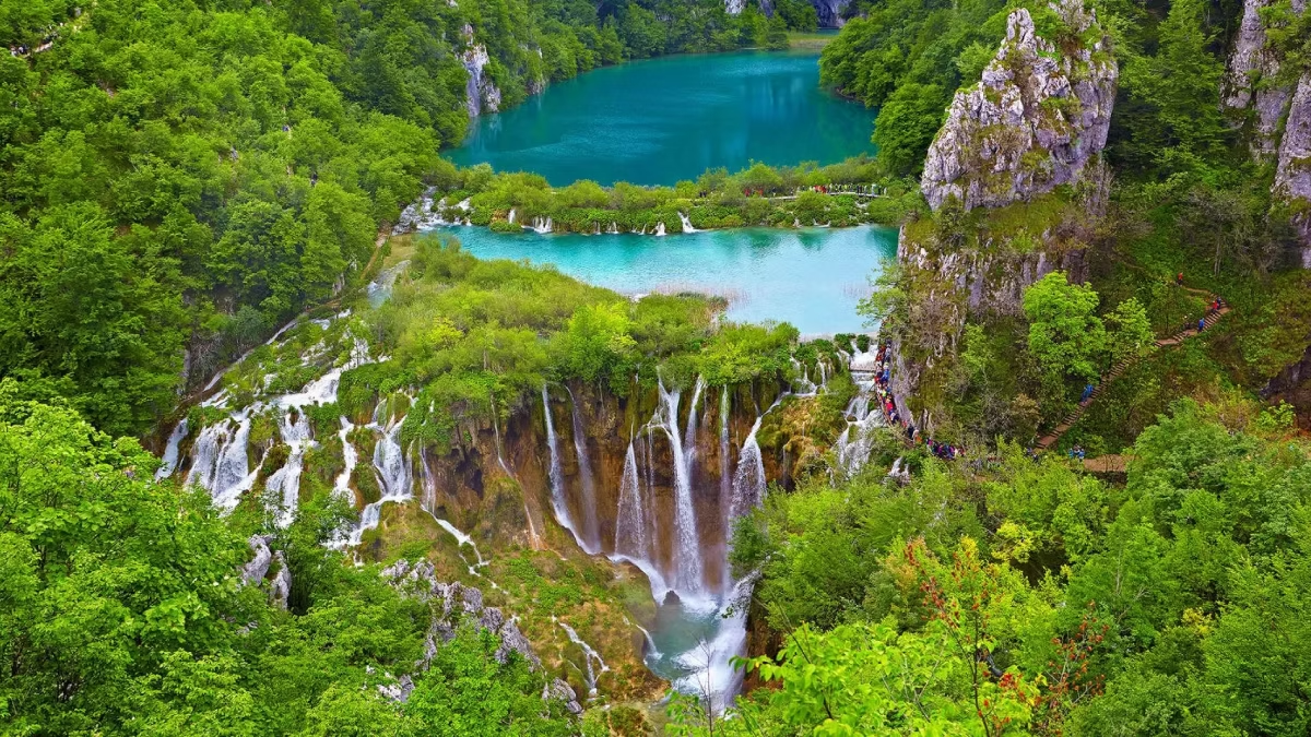
Kozjak — The largest and deepest lake in the park, at approximately 81.5 hectares. Kozjak forms the dividing point between the Upper and Lower Lakes systems and is crossed by the electric boat (included in the admission ticket). The boat journey across Kozjak — silent, slow, surrounded by forested limestone cliffs — is one of the park’s signature experiences. The lake is named after the local term for the wild goat that historically lived on the surrounding karst terrain.
The 4 Lower Lakes (Donja jezera)
The Lower Lakes are cut into a narrow limestone canyon — geologically different from the Upper Lakes, with steeper cliffs, more dramatic waterfall drops, and the iconic canyon boardwalk environment that defines most visitors’ mental image of Plitvice.
Milanovac — The first Lower Lake, directly below Kozjak. The Milanovački Slap waterfall — where Lake Kozjak’s overflow drops to Milanovac — is approximately 10 metres high. This is the first dramatic cascade encountered when descending from the Upper Lakes.
Gavanovac — A small, deep-blue lake. The Milka Trnina waterfalls between Milanovac and Gavanovac are named in honour of the opera singer and are particularly beautiful in high water conditions.
Kaluđerovac — The lake directly adjacent to Veliki Slap and the famous boardwalk sections. The path from Entrance 1 descends to Kaluđerovac first, making it the initial lake experienced by most visitors arriving via Route A, B, or C. Looking across Kaluđerovac toward the canyon walls and Veliki Slap is one of the park’s most striking views.
Novakovića Brod — The lowest and final lake, where water drains into the Korana River via the Sastavci waterfalls. The Sastavci — a dramatic fan of cascades across multiple channels — are most impressive viewed from the path above, near Entrance 1, where both Sastavci and Veliki Slap are visible in the same frame. This is the “postcard view” that most photographs of Plitvice Lakes replicate.
Why the Lakes Are Turquoise
The turquoise colour of the Plitvice Lakes is produced by the mineral content of the water — specifically calcium carbonate and magnesium — and the way light is absorbed and reflected at different depths. In shallow sections, the water appears vivid turquoise or green; in deeper sections it shifts to blue or grey. The colour also changes throughout the day as the sun angle changes, and across seasons as water temperature and algae content vary. The extraordinary clarity of the water (visibility of several metres) is a result of the water’s high purity and the ongoing filtration effect of the travertine barriers and surrounding limestone. This same purity and mineral balance is why swimming is prohibited — human contact disrupts the chemical equilibrium that produces both the colour and the travertine formations.
Key Facts
- Total number of lakes: 16 (12 Upper, 4 Lower)
- Total lake surface area: approximately 2 km²
- Height difference top to bottom: approximately 133 metres
- Largest lake: Kozjak (Upper Lakes, ~81.5 hectares)
- Smallest named lake: Several of the smaller Upper Lakes (under 1 hectare)
- Deepest lake: Prošćansko jezero (~37 metres at maximum depth)
- Tallest waterfall: Veliki Slap (78 metres, Lower Lakes)
- Rate of travertine growth: 1–3 cm per year
Frequently Asked Questions
Can you swim in any of the 16 lakes?
No. Swimming is strictly prohibited in all lakes, rivers, and waterways throughout the park. See our can you swim guide.
Which lake is the biggest?
Lake Kozjak — the lake that divides the Upper and Lower sections — is the largest at approximately 81.5 hectares. It is the only lake crossed by the park’s electric boat.
Are all 16 lakes visible from the walking routes?
All 16 lakes are accessible on the park’s walking routes, though some of the smaller Upper Lakes require the longer routes (H or K) to visit. Route C covers the majority of the lake system.
Why do the lakes look different colours?
Depth, mineral content, and the angle of light all affect the colour. Shallow sections appear vivid turquoise or green; deeper water appears blue or grey. The colours shift throughout the day and vary significantly between seasons.